
Overview
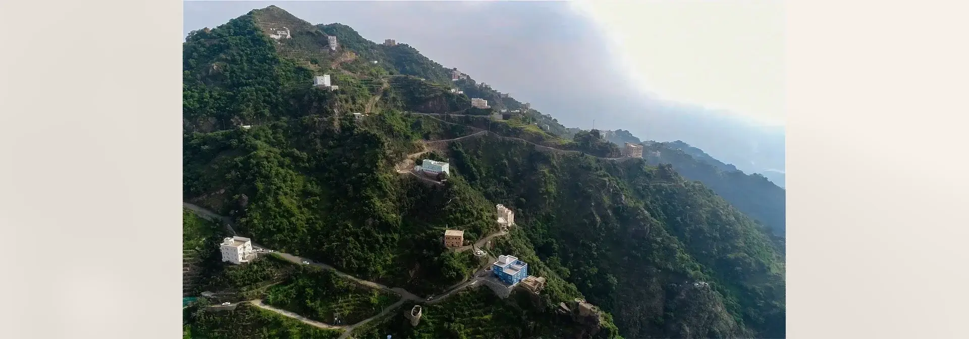
Jabal Fifa is a mountain in Fifa Governorate, east of the Jazan Region in south-western Saudi Arabia. It consists of a chain of peaks of varying elevation rising more than two thousand metres above sea level, and Al-Absiyah Peak forms its highest point, overlooking most of the mountains from every direction.[1]
Cylindrical stone houses, numbering more than 500, stand on the slopes and summits of the mountain, and beside them run agricultural terraces that climb from the valley up to the summit.[2][3]
Location and Formation
Fifa Governorate lies about 100 kilometres east of Jazan city, on the highlands of south-western Saudi Arabia, and its terrain rises more than two thousand metres above sea level.[2]
Wadi Damad and Wadi Jura surround the mountain on the north and west, and peaks of varying height follow one another along its chain.[1]
Peaks and Parks
Parks and high peaks are distributed across the mountains of Fifa; the best known of them is Al-Absiyah, the highest peak of the range, along with Al-Laghtha, Al-Kadra, Baq'at Al-Washal, As-Sirra, Qirda and As-Sama'.[3][1]
Among the most beautiful and best-known sites of the mountain is Sama', which overlooks Baq'at Al-Adhr, An-Nafi'ah, Wadi Al-Hajuri and Ad-Dafra; from it the cities of Jazan, Sabya and Abu Arish can be seen, together with the Jazan Valley Dam and Al-Arda, as well as the neighbouring mountains and the plains.[1]
Stone Houses and Terraces
The mountain preserves a distinctive architectural legacy in its cylindrical stone houses, which ranged from dwellings to forts and citadels and number more than 500 stone houses.[2]
Agricultural terraces adorn the slopes of the Fifa mountains from the valley to the summit; local people put their number at millions, and together with the old stone houses they attest to the depth and authenticity of the civilisation of the people of Fifa.[3]
Agriculture and Honey
The people of Fifa depend on agriculture and livestock herding; they grow aromatic trees and grains of all kinds, as well as pomegranates, custard apples, grapes, cacao, coffee, guava and tamarind, among other fruits and vegetables.[3]
Coffee is among the most important and finest crops of the mountains, and Fifa is known for the quality of its coffee and of its honey in its varieties: sidr, qatad and samar.[1][3]
Green Season and Fog
In the rainy season the terraces of the Fifa mountains are covered in greenery that draws visitors from within the region and beyond.[4]
Dense fog drifts between the trees of the mountain, refreshing the place with the scent of natural vegetation and lending that green landscape an added charm.[4]
Tourism and nature
Souq An-Nafi'ah
Souq An-Nafi'ah, the popular market of Fifa Governorate, is one of the oldest historical markets of the mountainous sector, and its founding dates to between 1140 AH and 1150 AH.[5]
For more than three centuries the market remained a centre of trade and a social and cultural meeting place that brought together the people of Fifa and the residents of the neighbouring villages, and it helped preserve the customs and practices bound up with the life of the local community.[5]
Development and Services
The Fifa Region Development and Construction Authority, established by royal order, is responsible for developing and improving the Fifa mountains across various fields; it set out its development plan and began implementing it in 1398 AH, and the roads it has cut through the rugged mountains total 175 kilometres at various sites.[7]
On 14 May 2015 the Ministry of Agriculture signed the contract for the first phase of the tree-planting project at Jabal Fifa and Balghazi in the Jazan Region, at a total value of 20,500,000 riyals and an implementation period of 30 months, to plant 200,000 trees of local coffee, mango, papaya and local custard apple, along with levelling and preparing the farmland and building and extending irrigation networks.[6]
Frequently Asked Questions
Q: Where is Jabal Fifa located? A: In Fifa Governorate, east of the Jazan Region, about 100 kilometres from Jazan city.
Q: What is the elevation of Jabal Fifa? A: It rises more than two thousand metres above sea level.
Q: What are the best-known peaks and parks of Jabal Fifa? A: Al-Absiyah, its highest peak, along with Al-Laghtha, Al-Kadra, Baq'at Al-Washal, As-Sirra, Qirda and As-Sama'; among its best-known sites is Sama'.
Q: What is the agriculture of Fifa known for? A: For high-quality coffee and honey in the sidr, qatad and samar varieties, along with grains, fruits, vegetables and aromatic trees.
Q: What are the most prominent heritage landmarks of Jabal Fifa? A: The cylindrical stone houses, numbering more than 500, the agricultural terraces stretching from the valley to the summit, and the historical Souq An-Nafi'ah.
Related topics
- RegionJazan RegionA southwestern Saudi region administered from Jazan city, combining the Red Sea coast, Farasan Islands, plains and mountains with farming, fishing, commerce and industry.
- Hospitality, food and drinkArabic Coffee in Saudi ArabiaArabic coffee in Saudi Arabia brings together preparation and hospitality, with roast levels, flavourings and customs varying among regions and households.
- HistoricVegetation Cover in Saudi ArabiaVegetation Cover in Saudi Arabia is the total of the native plant species and the varied ecological regions across the Kingdom, whose sites are developed, protected and monitored and whose degraded parts are rehabilitated through national programmes for afforestation, combating desertification and land rehabilitation.