Overview
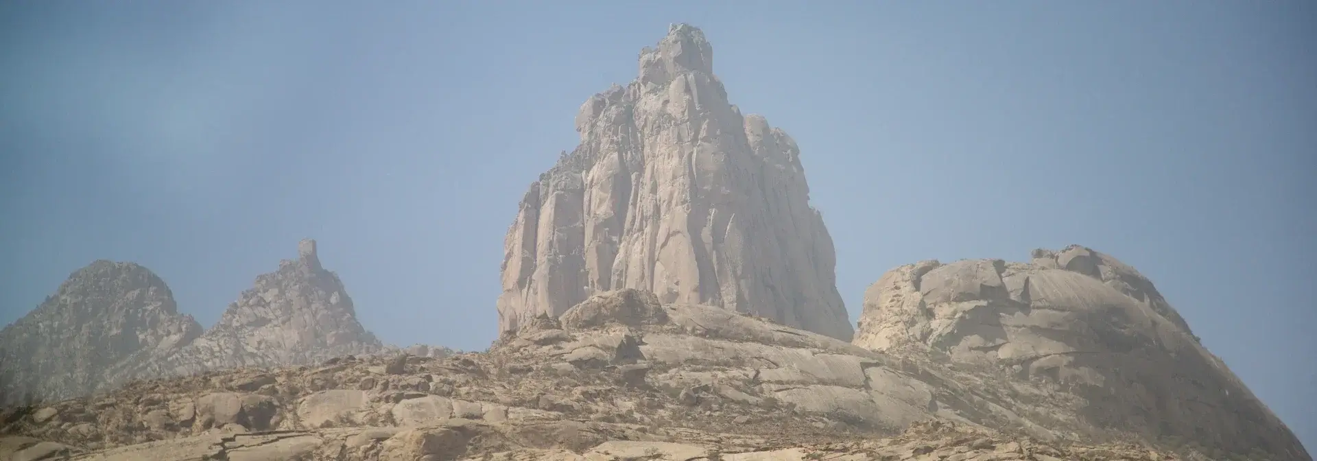
Jabal Shada Al-A'la is a rocky mountain in the northwestern part of Al-Makhwah Governorate in Al-Bahah Region, about 20 kilometers from the governorate. It is the highest mountain in the Tihama plain, rising 2,200 meters above sea level, and smooth rocks predominate over its terrain.[1][2]
The mountain forms an extension of the Sarawat Mountains, and a nature reserve bearing its name stands on it within the boundaries of the Emirate of Al-Bahah Region. Its slopes descend to about 500 meters above sea level at Wadi Malil.[2]
Location, Elevation and Rock Formation
The Jabal Shada Al-A'la Reserve lies in the northwestern part of Al-Makhwah Governorate, about 20 kilometers away. It is an extension of the Sarawat Mountains that reaches about 2,200 meters at its highest point at Musalla Ibrahim, then descends to about 500 meters at Wadi Malil.[2]
The mountain rises sharply as a giant granite mass forming a towering rocky outcrop from the heart of the Tihama plain, and its geological formation dates back hundreds of millions of years.[2] Facing it is Jabal Shada Al-Asfal, which lies between the governorates of Al-Makhwah and Qilwah, its granite rocks also predominating.[1][10]
Shada's Villages and Farming
Local residents inhabit about ten villages spread inside the reserve, among them the villages of Al-Saqran, Al-Sur, Al-Arba and Al-Jawwah, which the Zahran tribe inhabits, and the villages of Al-Kabsah, Al-Salatin, Al-Masai'ah, Al-Malaliyh, Qarn Al-Jarfah and Lahin, inhabited by the Ghamid tribe. Their population was about 2,500 people.[2]
Until recently these residents lived on growing the renowned Shadawi coffee, wheat, maize and millet, along with fruits such as bananas, pomegranates, guava and peaches.[2] This agricultural production is bound up with the mountain's standing as a home of coffee, and among the related topics on the platform is Arabic coffee in Saudi Arabia.[2]
Biodiversity and the Reserve
Jabal Shada was added to the list of nature reserves in the Kingdom in 1422 AH.[5] The reserve holds the highest level of natural plant diversity in the Kingdom, with more than 500 plant species recorded there, among them trees, shrubs, grasses, annuals and perennials.[2]
It is the natural and historical habitat of a group of wild animals, among them the Arabian leopard, the mountain ibex, the Arabian wolf, the caracal, the mongoose, foxes of several kinds, the hyena, the porcupine, the rock hyrax, the baboon and hedgehogs.[2] A large number of resident and migratory birds have been recorded in the reserve, among them the griffon vulture, the soaring falcon, the locust falcon, the shabout, the kite, the stork, the bee-eater, the Arabian babbler, the starling, the partridge, the collared dove, the bulbul and house sparrows.[2]
The reserve aims to conserve plant and animal diversity, to rehabilitate and breed endangered species such as the Arabian leopard and the mountain ibex, to raise environmental awareness of the importance of wildlife, to strengthen scientific research in managing its various components, and to support sustainable local development initiatives, foremost among them growing Shadawi coffee and beekeeping.[2] Among the related topics on the platform are the Arabian oryx and the Ibex Reserve.[2]
Antiquities and Inscriptions
The reserve holds archaeological inscriptions and historical sites, most notably the Shu'ayb Al-Jawf area and Jabal Musalla Ibrahim, and the inscriptions are thought to date back to before the Christian era, though their date and content are not known in detail.[2] Jabal Musalla Ibrahim is attributed to the devout ascetic Ibrahim Al-Adham, who settled the area hundreds of years ago and had a place of worship at the highest point of the reserve.[2]
The Musalla of Jabal Shada Al-A'la stands at the highest summit of the mountain, its area is about 9 square meters, and reaching it takes about four hours on foot from the nearest village to the summit, at an elevation of more than 2,200 meters.[7] Jabal Shada Al-Asfal hides among its granite rocks natural caves that ancient man inhabited thousands of years ago, as shown by the old Thamudic drawings and inscriptions that recount part of the history of settlement and life in the southwest of the Arabian Peninsula.[6] Both Jabal Shada Al-Asfal and Jabal Shada Al-A'la hold sites and historical antiquities dating back thousands of years.[7]
Protection and Development
The National Center for Wildlife oversees the protection of the reserve, carrying out a programme to curb unlawful hunting, indiscriminate tree felling, encroachment on public land, dumping of waste and damage to rocks, and inspectors work there on a permanent basis.[2]
Mounted and on-foot patrols set out daily from the reserve's management centre to cover all its areas, in cooperation with the local community, representatives of local administration and government institutions.[2] On the agricultural side, the branch of the Ministry of Environment, Water and Agriculture in Al-Bahah Region, through the ministry's office in Al-Makhwah Governorate, organised a workshop entitled "Agricultural Operations Accompanying the Coffee Crop" at a farm on Jabal Shada Al-A'la.[8] The municipal council of Al-Makhwah Governorate surveyed the needs of the villages of Jabal Shada Al-A'la for services such as asphalting and lighting of roads in the villages of Al-Masai'ah and Al-Sudairin.[9]
Access Routes and Tourism Status
The historical road to the summit of Shada was built in 1388 AH by the people of Shada. It links the summit of Shada with Al-Makhwah Governorate over a length of 10 kilometers, begins at the village of Namar west of Al-Makhwah, and is paved with stones.[3] The asphalted road from the foot of the mountain up to the summit of Shada is about 11 kilometers long.[4]
The Jabal Shada Al-A'la Reserve is a tourist destination visited by people from inside the Kingdom and beyond for its natural features, rocks, inscriptions and historical sites, alongside its standing as a home of Shadawi coffee.[2] The Shada mountains, with their lower and upper summits, are clad in cloud and mist in the winter season, a scene that draws hikers and visitors seeking warm weather in the Tihama sector, and among the related topics on the platform is Dhi Ain village.[10]
Tourism and nature
Frequently Asked Questions
Q: Where does Jabal Shada Al-A'la lie? A: In the northwestern part of Al-Makhwah Governorate in Al-Bahah Region, about 20 kilometers away.[2]
Q: What is the elevation of Jabal Shada Al-A'la? A: It rises 2,200 meters above sea level and is the highest mountain in the Tihama plain.[1]
Q: What distinguishes the biodiversity of the Jabal Shada Al-A'la Reserve? A: More than 500 plant species, wild animals among them the Arabian leopard and the mountain ibex, and a large number of resident and migratory birds.[2]
Q: How many villages lie inside the reserve? A: About ten villages of the Zahran and Ghamid tribes, which were home to about 2,500 people.[2]
Q: How is the summit of Shada reached? A: Along the asphalted road that extends from the foot of the mountain to the summit over about 11 kilometers, or along the historical stone-paved road built in 1388 AH, 10 kilometers long, from the village of Namar.[3][4]
Conclusion
Jabal Shada Al-A'la combines an elevation of 2,200 meters as the highest summit in the Tihama plain [1], a towering granite formation and an extension from the Sarawat Mountains [2], villages, farming and inscriptions [2][6], biodiversity at the Kingdom's highest levels [2], a reserve working to protect and develop it [2][8], and roads that ease access to it together with visitors drawn from inside the Kingdom and beyond.[3][4][10]
Related topics
- RegionBahah RegionA southwestern Saudi region administered from Al Bahah, combining Sarawat uplands and Tihamah, with historic villages, agricultural terraces and vegetation in its mountain landscapes.
- HistoricDhi Ain VillageA heritage village in Al-Makhwah, Al-Bahah, on a white rock hill, dating to the end of the tenth century AH and named after the spring that waters its farms.
- Hospitality, food and drinkArabic Coffee in Saudi ArabiaArabic coffee in Saudi Arabia brings together preparation and hospitality, with roast levels, flavourings and customs varying among regions and households.
- HistoricArabian OryxThe Arabian Oryx, also known as the wadhi oryx, is a species of wild mammal and the largest wild mammal in the Arabian Peninsula. It was absent from its natural habitat in northern Saudi Arabia for about ninety years, then was resettled in protected reserves and released in Uruq Bani Ma'arid Reserve and King Salman bin Abdulaziz Royal Reserve.
- HistoricAl-Waol Ibex ReserveAl-Waol Ibex Reserve is a nature reserve in the Riyadh Region, supervised and managed by the National Center for Wildlife, located about 120 km south of Riyadh city within the Tuwaiq Mountains range. It was inscribed on 9 October 2024 in the Green List of the International Union for Conservation of Nature, becoming the first reserve in the Kingdom to meet its standards.
Sources & references
- Saudi Press Agency (SPA) — Jabal Shada Al-A'la is the highest mountain in the Tihama plain
- Saudi Press Agency (SPA) — The Jabal Shada Al-A'la Reserve in Al-Bahah Region
- Saudi Press Agency (SPA) — The historical road to the summit of Shada
- Saudi Press Agency (SPA) — The asphalted road to the summit of Shada
- Saudi Press Agency (SPA) — Adding Jabal Shada to the list of nature reserves
- Saudi Press Agency (SPA) — The caves and inscriptions of Jabal Shada Al-Asfal
- Saudi Press Agency (SPA) — The Musalla of Jabal Shada Al-A'la
- Saudi Press Agency (SPA) — Workshop on agricultural operations accompanying the coffee crop
- Saudi Press Agency (SPA) — The municipal council's tour of the villages of Jabal Shada Al-A'la
- Saudi Press Agency (SPA) — Cloud and mist over the two summits of Jabal Shada